Frequently Asked Questions
The coastal policy varies along the south coast of Hayling Island and is divided into multiple Option Development Units (ODUs), with ODU9 from Eastoke Corner to Inn on the Beach and ODU10 from Inn on the Beach to North Shore Road. ODU9 is a ‘Hold the Line’ policy at the east and central areas of the island, with ODU10, has property resilience policy in the north and to “allow the coast to evolve as naturally as possible alongside private maintenance or replacement of defences” at West Beach and Gunner Point. This, and decisions taken by Havant Borough Council regarding this policy, determine whether the structures are maintained or removed when they become significantly damaged.
The groynes at West Beach were primarily removed due to the considerable health and safety risk they posed from their condition at the time, however the decision not to replace them was driven by the policy for the site.
In ODU9, the Hold the Line policy is managed through Beach Management, which is the process of taking shingle from where it has built up and placing in area where it has been lost. This process is carried out along South Hayling to reduce the risk of flooding to the homes at Eastoke.
Havant Borough Council’s policy decision for the sea defences at West Beach was approved in 2008 to remove the life expired structure as it failed and/ or became a health and safety risk. The revetments and timber groynes at West Beach were built in mid 1970s and the average design life for timber structures in an open coast environment, such as Hayling, is approximately 20 years. Despite regular maintenance and repairs, at a large cost of over £1.4m to the Council since installation, the structure was beyond its serviceable life and continued to fail. The western end of the structure was considered a significant health and safety risk to the public and removed in 2012. Additional sections of the structure have also been removed, with the most recent removal taking place in 2020.
As there are no residential properties protected by the structure from coastal flood and erosion, there is no viable business case for central government funding to remove and replace the structure. Therefore, reconstruction of a comparable structure on a like for like basis is not economically viable or affordable to the Council.
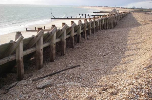
Image: Groyne 57 looking west, showing gaps in horizontal planking and loss of material behind the defences (5th Dec 2011).
Predicting the response of the coast is both challenging and prone to uncertainty, particularly down drift of coastal structures and near complex harbour inlets. In 2017 the predicted beach response at West Beach under a ‘managed scenario’ was estimated to help inform future land use and development. This assumed annual beach recycling from Gunner Point, thereby creating a haul route in front of West Beach. These predictions were based on the actual retreat of the beach crest following removal of the first section of the timber revetment for the period 2012 to 2017. This was projected landward, after which the average rate of annual erosion was applied. Sea level rise was also added to this average rate, based on the well known Brunn rule, leading to a series of risk zone predictions over the next 100 years.
In reviewing the response of the beach since 2017, this approach was found to be less reliable. Therefore in 2020 the erosion risk zones were replaced with a series of Adaptation Zones which are presented in the following figure. This figure shows the Coastal Adaptation Zone of where modelling has predicted the beach crest could roll back to following the removal of the failed structure in 2020. This figure also shows the beach crest as surveyed in February 2026, which is following the line of the Adaption Zone as the model predicted.
This modelled adaptation zone is dependant on the remaining timber structures (Groyne 53, immediately west of the Inn on the Beach, and Groyne 58, at the boundary of the Golf Course) being in place. Without these structures, the adaptation zone will change due to coastal processes in the area.

The Coastal Partners carry out routine surveys and monitoring of the beaches at South Hayling, include at West Beach. Two different types of survey are carried out along this frontage: profile data and baseline data. Profile data is collected twice a year (Spring and Autumn) and consists of data collected on set profile lines from the car park edge to the Mean Low Water Spring level. Baseline data is collected once a year, in the Spring, and involves the full beach being surveyed to collect levels. This allows us to build a ground model showing the full extent and levels of the beach and the beach crest position.
Our routine beach surveys show that erosion has occurred at a greater rate in the east nearest the Inn on the Beach, with the beach in the west, nearing the golf course remaining more stable.
Key findings from the Storm Analysis study carried out by SCOPAC suggest that “central south coast of England has experienced a trend of increased storminess over the past 20 years in the form of increased wave period, swell waves and bi-modal seas”. This can be seen through the increased erosion at sites such as West Beach. We will continue to monitor the beach and any coastal processing trends.
In short, no, as the Flood Defence Grant in Aid funding from central government can not be used for the maintenance of coastal structures. Funding for any works at West Beach will need to be through HBC and private landowners.
The Environment Agency funding awarded to HBC is to manage flood risk at Eastoke, through the recycling and import of shingle. The shingle is placed on the beach at Eastoke to help reduce flood and erosion risk to the high number of properties and residents here. Funding for routine maintenance of coastal structures is sourced from HBC.
Should future development of West Beach be considered, the results of coastal monitoring at this site and the coastal risk zones will need to be taken in to account before any decisions are made.
The beach can be subject to ‘cliffing’ of the compacted ground which needs careful management. If trimmed to a slope, the next stormy period will wash the loose material away and it will quickly reform into a new cliff, increasing the rate of erosion. If left, natural process are likely to breakdown and rework the cliffing, but this can take time.
NORSE SE operatives conduct daily patrols on Hayling seafront. Debris on the foreshore will be removed where possible to manage the risk to the public.
The car park surfacing, and maintenance of Council owned beach huts, is the responsibility of Norse SE. The erosion of West Beach is monitored on a regular basis to ensure the beach huts are not placed at risk. The repositioning of beach huts following stormy weather is also carried out by Norse SE, charges to the licence holder may apply as per the beach hut licence agreement.
The Local Plan sets out West Beach as a regeneration zone in a regeneration area, and therefore plans may develop in line with the Local Plan and Seafront Ambition document.
The importance of the Inn on the Beach in managing the wider coastline is recognised in the Hayling Island Coastal Management Strategy, which highlights that it currently acts as a terminal structure which allows sediment to accumulate to the east. As such, the strategy advises it is necessary to either maintain the existing defences at Inn on the Beach or replace them with other structures to continue to enable sediment to accumulate along the eastern seafront. The Strategy and its Action Plan was adopted by Havant Borough Council in December 2024 and approved by the Environment Agency in July 2025.
The Coastal Strategy will include adaptive pathways to allow us to more flexibility to manage risks and adapt to changing conditions over time. For example, if landowners wish to maintain or implement (and fund) their defences in the future, the Strategy does not preclude this.
The Council has approved £900,000 to work collaboratively with the neighbouring landowners, Hayling Golf Club and the Inn on the Beach, to implement a “do minimum” adaptable and sustainable solution to gain more certainty on the coastal evolution of West Beach.
Should future development of West Beach be considered, the results of coastal monitoring at this site and the coastal risk zones will need to be taken in to account before any decisions are made.
The land behind West Beach, South Hayling is an environmentally designated Site of Special Scientific Interest (SSSI) and has areas featuring rare wildlife and nationally important plants.
This land is protected and any works that could impact on the SSSI would need prior approval from Natural England. A car park would ‘damage’ the condition of and species within the SSSI and therefore would unlikely to achieve consent.
"The Southsea Coastal Scheme is the UK’s largest local authority-led coastal defences project, worth more than £185M. It will stretch for 4.5km from Old Portsmouth to Eastney, and help to reduce the risk of flooding to more than 10,000 homes and 700 businesses. Approximately 4,000 of these properties are at risk of direct threshold inundation.”
The shear scale of properties at coastal flood and erosion risk for the Southsea Flood Cell (over 10,000 homes), gives it a high priority nationally and unlocks funding from Defra to deliver the scheme.
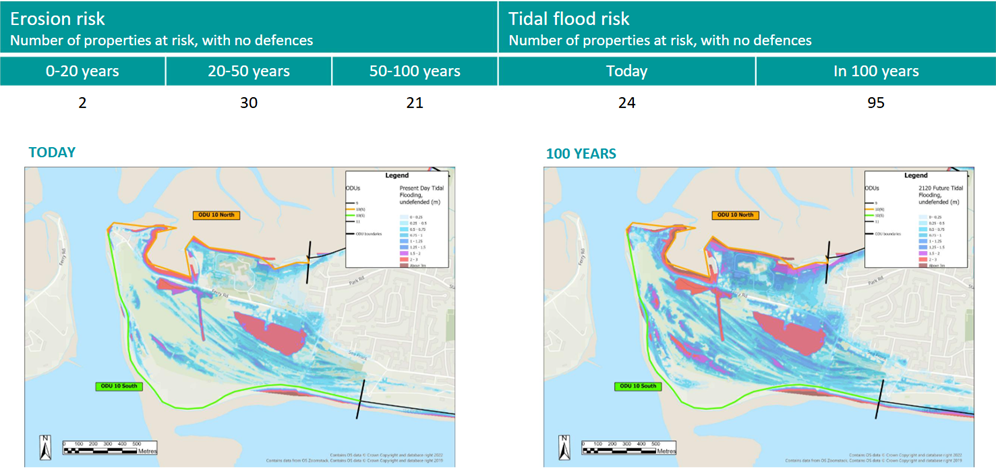
Within the area of West Beach, Hayling, the Hayling Island Coastal Management Strategy identified that the number of properties at flood risk within ODU10 is 95 in 100 years time. These are thought to be at flood risk from the northern frontage and not the West Beach area, and therefore is unlikely to attract funding from central government.
In 2024, the Council allocated funding to work collaboratively with Hayling Golf Club (HGC) and Inn on the Beach (IotB) to review the West Beach area and find an affordable solution to tackle erosion at West Beach.
We are currently on Phase 1 of a 4-phase project and by the end of this year, the Council aims to have affordable outline design options in place. If enough funds can be secured to construct defences in this area, the Council will apply for the necessary licenses and consents. Once these have been obtained, the project will progress to construction.
This area is unlikely to receive central government funding due to the small number of properties at risk, therefore, the scale of the project and whether erosion can be fully addressed, will depend on the amount of funding and contributions from the parties involved.
In the interim, the council is programming some minor timber maintenance works to try to retain the structures in advance of the winter season.
For Frequently Asked Questions about Eastoke, please visit the FAQ page
For Frequently Asked Questions about the Hayling Island Coastal Management Strategy, please visit the FAQs page
History Of West Beach - FAQs Related News
- There are currently no related news articles.